The Oregon Trail in Nebraska:
Following the Great Platte River Road
The Oregon Trail enters Nebraska’s southern border with Kansas just west of the small town of Odell. Pioneers continued northwest from here to Rock Creek Station and on to Fort Kearny where they connected with the Platte River. The Great Platte River Road that stretches across the state became the pioneers’ highway west. The Platte, sometimes described as “a mile wide and an inch deep,” guided not only emigrants headed for Oregon, but gold seekers going to California, Mormons heading for Utah, and Pony Express riders carrying mail between St. Joseph, Missouri and Sacramento, California.
No state, including Oregon, is more closely associated with the Oregon Trail than Nebraska. Consider many of the trail’s best-known landmarks including Courthouse Rock, Jail Rock, Scotts Bluff, and Chimney Rock were within sight of pioneers following the Great Platte River Road. The trail through Nebraska was generally considered the easiest stretch of the 2,100-mile trip, at least until pioneers encountered hills west of present-day North Platte. Up to this point the land was flat, water was readily available, and food for livestock was generally plentiful near the river. The terrain became more difficult once emigrants passed west of confluence of the North and South Platte. In the early years of the trail pioneers continued for a distance along the south bank of the South Platte before crossing the river and heading north to navigate infamous California Hill. A short distance north, wagon trains encountered the steep downhill grade of Windlass Hill and access to the fertile meadow at Ash Hollow. Each of these locations is accessible to present-day adventurers who wish to follow the path blazed by the emigrants. Interesting Oregon Trail locations in Nebraska include:
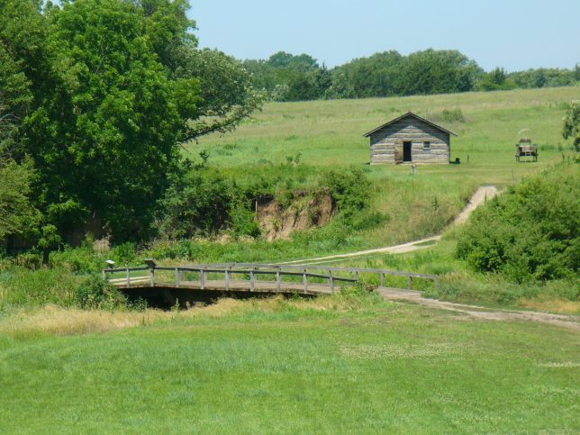
1) Rock Creek Station – An important stop for Pony Express riders and emigrants traveling the Oregon Trail is now a Nebraska state historical park. A visitor center with trail exhibits sits beside an impressive swale cut by pioneer wagons as they ascended a hill north of Rock Creek. A reconstructed bridge, replica wagons, and buildings are accessible by following a walking path to the bottom of the hill. A pleasant state-operated campground is nearby. View our video of Rock Creek.
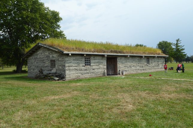
2) Fort Kearny – This military post established in 1848 to protect emigrants heading west to Oregon and California was also a stop for Pony Express riders. Fort Kearny (pronounced Carney and spelled differently than the nearby town of Fort Kearney) is part of a Nebraska state historical park that includes an interpretive center, reconstructed buildings, and replica Oregon Trail wagons. View our video of Fort Kearny.
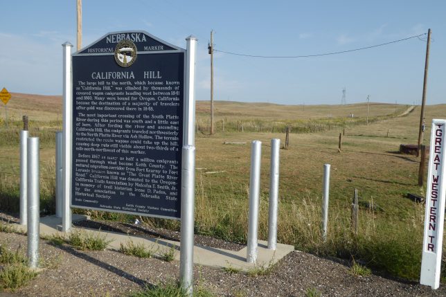
3) California Hill – An impressive landmark along the Oregon Trail, California Hill represented the first major grade encountered by the emigrants during their westward trip. Crossing the South Platte west of the present-day town of Ogallala, pioneers were required to navigate California Hill as they moved north toward the North Platte River. The hill is a short distance north of U.S. Highway 30 alongside a rough gravel road, but the drive is worth the effort to gain access to and walk along ruts cut by wagons being pulled up the 1 ½-mile long hill. View our video of California Hill.
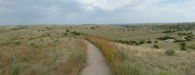
4) Windlass Hill – North of California Hill, Windlass Hill offered a steep downgrade required of wagon trains to reach Ash Hollow and the North Platte River. Pioneers locked the wheels of their wagons to avoid an out-of-control descent down the hillside. A paved walking trail leads from a parking area to the top of the hill where visitors gain an outstanding view of the route of the trail and the lush meadow pioneers found to the north.
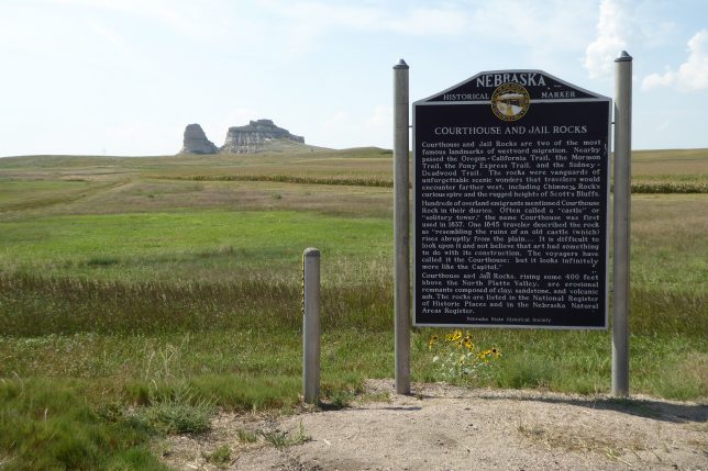
5) Jail Rock and Courthouse Rock – Two famous landmarks a short distance south of the North Platte River were well-known to pioneers and are easily visible to travelers driving along U.S. Highway 26. A paved road in the small town of Bridgeport leads south to the formations.
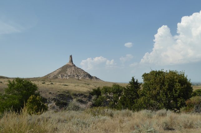
6) Chimney Rock – The most famous of the trail’s landmarks has suffered considerable erosion and is no longer the majestic formation observed by pioneers, but today’s travelers generally experience a thrill when it first comes into view. Highway 26 on the south side of the river passes relatively close to Chimney Rock that is accessible by vehicle. An interesting visitor center (fee charged) with an excellent view of Chimney Rock is south of Highway 26.
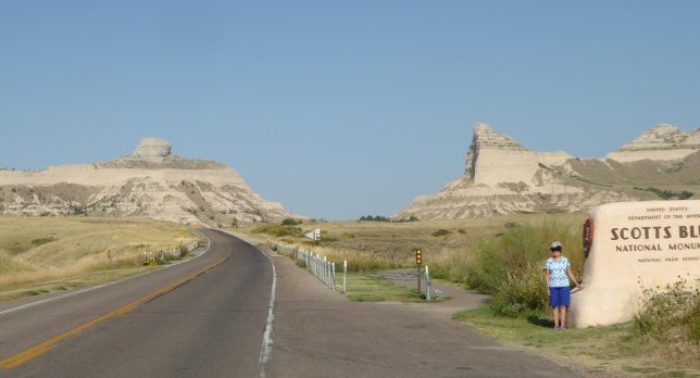
7) Scotts Bluff – Early wagon trains skirted the imposing bluff by looping south through Robidoux Pass. Following the 1850 opening of Mitchell Pass, wagons moved single-file and cut deep ruts that remain visible to today’s visitors. Scotts Bluff National Monument preserves the ruts and offers an excellent visitor center that interprets the trail and the pass used by pioneers. A separate room contains numerous paintings of William Henry Jackson. Visitors can walk along the wagon ruts just west of the visitor center. Replica wagons are on the site. A paved road leads to the top of the bluff where outstanding views are available. The visitor center has a handout that directs travelers to the trail’s old Robidoux route.